QTopo Digital Mapping
As we all know, the Internet has changed many areas of life such as government services, and this includes topographic map provision. Locally, the Queensland Government's excellent QTopo website, https://qtopo.information.qld.gov.au/ provides access to free digital maps, and other location data. Here's a quick tour of Version 2 of the QTopo website.
Note: QTopo map sheets are now released with GDA2020 datum, which differs slightly (about 2m) from GDA94 or WGS84. Initially, the geo-referencing in the standard map sheets appeared to differ from the marked grid by up to 50m in some maps – not though in custom print maps. This is no longer the case with currently available geo-referenced PDF maps.
.
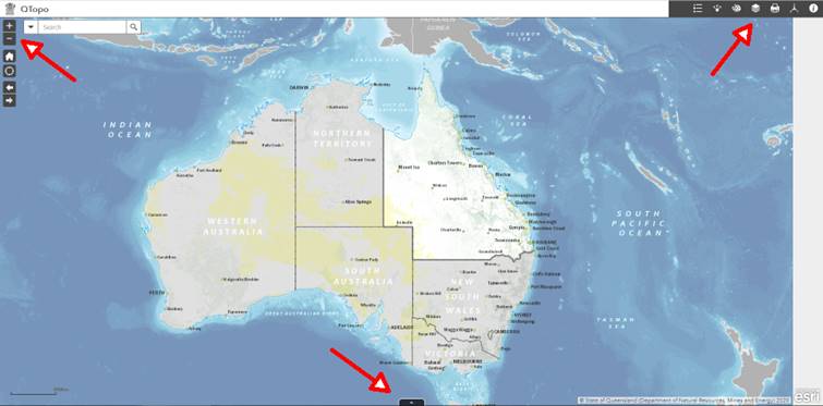
When the website loads (after you accept the Terms and Conditions), you can see a map of Qld, the usual zoom in/out buttons at top left, a series of buttons at top right, and a pop-up button at centre bottom for map/location/data selection that QTopo refers to as an Attribute Table (marked with red arrows). As most walkers will be wanting to either download a standard map sheet, or generate a printable map for a specific area, these are the only options discussed here.
First, zoom in to the area of Qld where you would like a map, and at the scale you would like. As you zoom in, the screen shows the boundaries of the standard map sheets, at 1:100,000, then 1:50,00 and then 1:25,000. 1:10,000 scale maps are also now available for most parts of Qld.
Download a standard map sheet.
The easiest option. Simply Click on the screen at the position where you want the map. A pop up will appear, with a link to download the Topo Map at that position, in georeferenced PDF format. Note that all PDF format maps on QTopo are georeferenced. This means that with the right app, any position on the map can have its latitude/longitude or UTM coordinates displayed.
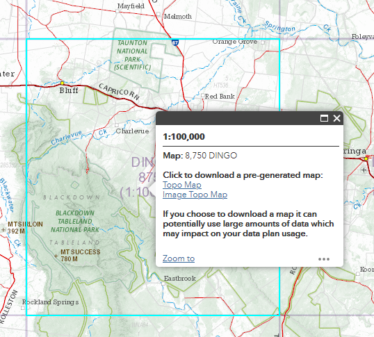
QTopo website showing the pop-up link to the specified 1:100,000 scale map
(map boundary of the selected map highlighted in the background).
Full topographic maps are now available for anywhere in Qld at map scales 1:25,000, 1:50,000 and 1:100,000. Most areas, particularly urban, now also have 1:10,000 scale maps. Which map scale gives the "best" map for a particular area will depend on a number of factors, particularly where the area of interest lies in relation to map boundaries. For example, Mt Sleipner in the Berserkers lies near the edge of a 1:25,000 scale map, but is roughly centred on the 1:50,000 scale map, and the latter map contains as much detail as the 1:25,000 scale map. Zoom the screen map in or out as appropriate to see the desired scale map boundaries.
File sizes are around 15MB, and are designed to be printed on A1 sized paper (59 x 84cm), however on many occasions only a part of the map needs to be printed, and this can be selected using the Snapshot feature of the PDF reader (check what resolution the Snapshot selection uses if your selection is blurry). Paste the selection into a paint/image edit app. The map images benefit from a sharpening operation if your image editing program has it, and despite the name, an Unsharp Mask gives best results.
Generate a custom printable map.
What if the area of interest lies near the boundaries of any of the available map scales (e.g. Mt Atherton at Byfield)? Then it is possible on QTopo to generate your own map. Make sure before you do this that you have zoomed the screen map in to better than the desired map scale and centred the desired area on screen before you request map generation. To see the current scale, click on the Coordinate button at top right.
![]()
Coordinate button.
Now click the Custom Print Button at top right.
![]()
Custom Print button
Despite QTopo referring to this as a "Print" button, the result will be a file in either PDF or PNG format that you download.
Here's an example of a custom print screen for the area around Stony Creek Falls, Blackdown Tableland.
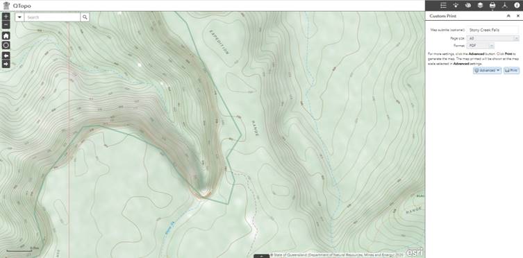
Example screen for Custom Print
Below is a close up of the Custom Print details, with an optional map subtitle, in A3 page size, with a 1:25,000 map scale selected after clicking on the Advanced button. Note that the resulting map is not a "what you see is what you get" representation of the selected area, but a map at one of four fixed scales, centred at the screen mid-point. The default map scale is 1:10,000 (which may not match what you see on the screen).
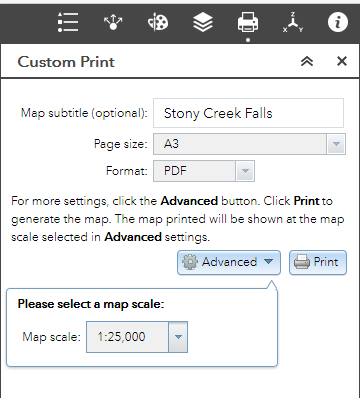
If you now click on the Print button, the map generation process commences, and after a short while, a link to your map appears. Links to maps previously generated in the current session also remain until you click the Clear Prints button (note all links are called "QTopo Map" unless you provide a map subtitle).
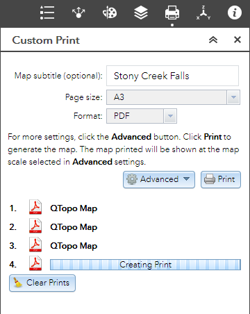
The maps are generated in landscape format. A3 maps have a legend, A4 maps do not.
You will possibly need to experiment a bit to get the map coverage you require.
Further help?
QTopo has a Help link in the drop down screen that appears when the About QTopo button (top far right) is clicked.
Differences between
Version 1 and 2 of QTopo
Apart from the much simpler interface, QTopo 2 does not appear to offer custom maps with Web Mercator projection. All custom maps now use the GDA2020 datum and grid.
Errors and omissions
on Qld maps:
Reliability of map information, eg roads, has improved, but caution is still required.
Other digital
mapping.
All the other Australian states also provide online digital mapping, but only NSW (NSW maps) has free downloads. Map scales vary across the state, with 1:25,000 in the east, to 1:100,000 only in the far west of NSW. 1:25,000 and 1:50,000 maps are double width compared to Qld maps of the same scale. NSW online maps use "Lambert Conformal Conic" projection, not UTM. South Australia has Nature Maps that allows for selection and download of topographic maps for the state.
You may also be able to download a suitable map for the eastern Australian region from Get Lost Maps (maps only available in OziExplorer or GeoTIFF format), or generate a map in GeoPDF format for a particular area using the US CalTopo website.
Free map downloads are also available for all of New Zealand (NZ maps) at 1:50,000 and 1:250,000 scales. Note that NZ has its own mapping grid that is different to standard UTM. Details are given on the NZ mapping website.